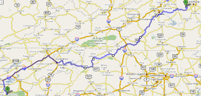
Sunday, June 26, 2011
A Sunday Drive
Picture post
Tuxedos show us not to resist duality, but to embrace it. There is nothing in life that is free of a positive and a negative dual nature. The good news is that despite being in the midst of negativity, there is a positive solution. In every cloud, there is a silver lining waiting to be discovered. And within that same cloud is the potential for a rain storm.
The gray zone of life is an illusion; it is a place of our own making. When situations become uncomfortable, our human nature requires that we find an underlying reason for our circumstances. We often blame someone else for creating our drama. We don’t want to look at both aspects — the black and the white, the good and the bad, the positive and the negative."
Wednesday, June 22, 2011
The Portsmouth, Great Falls, and Conway

Monday, June 20, 2011
Power line dreams: Return to South Berwick
Sunday, July 26, 2009
The gate at the Boyd Rd. end, which had been closed last summer, has been open for at least a few months. I parked at the Finson Farm (the CSA that I'm a member of), a short ways up the road. The gate at what is now Country Time Kennels (and I believe used to be Marlee Animal Shelter) was ominously closed.
Serenity Lane is straight as an arrow for a while and quickly picks up a tall chain-link fence that marks off Pike's property. You can't see anything industrial through the trees. Maybe 3/10 of a mile in, there's a small cemetery on the right. It appeared to be a Jepson family burial ground, and someone had been added as recently as 2001. Apparently the Jepsons have been in Wells for almost 300 years--anyone know any of the current generation?
As an aside, ghost hunting back here would have been about 5x as scary as doing it back on 9B. For the psychology project where we had Emily (among others) dress up as ghosts and recorded people's reactions to seeing them, we could have used this graveyard and then had somebody close the gate, "trapping" us. And we could have had somebody over at the kennel/shelter getting the dogs riled up and barking like crazy. That was a missed opportunity.
At this point, the road was a good dirt road with some gravel sporadically spread on top. You could tell that typical passenger cars could and had been down it. Things were pretty quiet for a while, with only a few "Blasting zone--keep out" signs disturbing the peace. The one gate in the fence not only was locked, but had large boulders on the other side that precluded any vehicle larger than a scooter from getting out. An old stone wall ran down the other side of the road for a while before petering out.
Maybe 3/4 of a mile in, the fence and the road took a left turn--not quite 90 degrees, but apparently we had reached the back of the Pike property, when a red sedan was suddenly headed my way. It looked like there were 3 people inside but I avoided eye contact and breathed a sigh of relief when the driver didn't stop.
It looked like the sedan had pulled out into the road, and indeed a side road that looked less-traveled soon popped up on the right. Somebody had duck-taped an empty bag of Quik-rete to a tree and, a short ways down the "driveway", had clumsily attached a "Keep Out" sign to a too-thin branch. I still kept out. Soon, the fence changed from chain link to wire. The road became rougher, muddier, and more grown in and as the dusk set in, it got incredibly buggy.
Soon, I came to what I assumed was an old gravel pit. It was now a small pond with a steep rock face rising on one end and assorted boulders on another. Either they had been strategically arranged or mankind got very lucky as the boulders form a rough semicircle. As you approach, the boulders are covered in graffiti (the "Guitar Hero" writing and drawing of a guitar player is presumably fairly recent, and who knows about the picture of a cat and the scrawled "MEOW".) There was a fire pit and a bunch of trash. I thought that it was similar to, but not the same as, a spot I came to a couple of summers ago. I believe that one was on one of the trails between Cheney Woods Rd. and the Newhall Road extension, but my memory could be scrambled.
Here's a map of the area:
You can see on the map that the marked road ends at some weird purple stuff. Similar purple stuff just off of Route 9B between the Turnpike and Loop Rd. is labeled as "Sand and gravel pit". By the way, I got the map from http://www.digital-topo-maps.com/, and its get-a-map technology is great--once you have a topo map, you can zoom in and out and drag it just like a regular Google Map.
On another side of the pond was a large, very rusted piece of equipment. It looked sort of like a crane with a thin, circular piece of metal on one end that looked like it would have had run some kind of belt or pulley.
I wish I had thought to check what the fence did around this spot...is the piece of equipment now outside of the Pike boundaries? Or is this where you could"break in"?
The road turned into an ATV trail here, albeit one with quite a few recent tracks. I followed it for a while, bypassing a number of muddy patches, before the mother of all mud patches turned me around. I was surprised to not have reached Cheney Woods Rd, but looking at the map now, I shouldn't have been. One narrower but discernible trail had left to the right--looking at the attached map, it was probably headed for the Allen Rd. extension.
Having now been gone for quite a while, I was starting to get a little creeped out and didn't dawdle on the return trip. I was my garden work clothes (long-sleeved shirt and lined wind pants) and the air was not cooling off so I was sweating buckets. I won my race with the sun back to the car, but, surprisingly, the creepiness continued into the drive home.
I hadn't stopped sweating yet and soon had sweat running into my eyes, which stung to the point of me being barely able to keep them open. This was on the part of Thurrell Road where the road makes a few sharp turns and the asphalt is badly eroded. I kept it together for what felt like eternity before finally getting to a good spot to pull off the road.
It was getting foggy, and a short while after starting up again, I came around a turn and thought I had lost it. I was driving straight into the woods! No, it was just a branch that had fallen across the road. Fortunately, it was suspended high enough in the air that I could drive under with just leaves grazing the top of the Honda.
The really weird part (at least to me) was that 1) The branch hadn't been there when I drove through there about 8 hours before and 2) Had the branch been there 2/3 hours before, when I was driving to the farm, I wouldn't have seen it as I decided to take the "front way" of Route 4 for the first and only time in my life. It was as if those Jepson ghosts knew I was coming and conspired to make the experience as creepy as possible.
Next up is to wait until things dry out a bit and then try trails off of Cheney Woods Rd. until I find the other end of this one.
Sunday, March 15, 2009
Sunday 3/15
Music: OSI - Free
Sunday was warm and sunny from the start, but I was going nowhere fast. Finally, shortly after 1:00, I emerged from the blue room, threw open all of the shades, and stumbled out the front door.
Irregular melting has left monorails in some spots and muddy patches in others. I head out with the classic long-sleeve/short-sleeve t-shirt combo, but returned to grab the green fleece. After feeling cold so often of late, I welcome the opportunity to be a little too warm. I pace past the mailboxes, up Alder, and left onto Willow. It's remarkable how high a baby hill, nearly imperceptible in a car, can feel when you're on foot.
There's no doubt about this weather, so quite a few people are out and about, a few even carrying sports equipment. I spend most of the 0.75ish-mile Willow Street slowly gaining on a pair of woman in typical sweatshirts and tights, just frumpy enough to avoid the obvious yuppie pigeonhole. As I get close, I debated my options. Stay quiet and risk surprise or breath unnaturally loudly? Keep up the pace and nearly run them down or walk awkwardly slowly to stay back? I wonder about gender roles, sexual predators, and how scariness and skinniness interact before taking the first convenient opportunity to pass on the left.
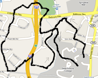
Here's the route:
When you think about it, the Old Mill/Agamenticus Estates region has an awful lot of people living in a small area. It's no surprise that there are small crowds at the new "The Barn" teen center on the corner of Willow and Agamenticus and at the convenience store/"game center" across the street. After a few safe steps on the wide shoulders of Agamenticus Rd., I bear right past the Dead End sign onto an unmarked dirt road--Crooker Lane under the blackout above.
The road runs along the edge of a cemetery for a while, and then next to a field. For a brief stretch, there are clearings on both the left and right. Maybe a quarter mile in, I start to bear down on a lone house, and with a number of vehicles parked out front, it earns a "vaguely threatening." I swing right into a gully, ascend the tiny headwall, hop a chain-link fence, and walk back in the direction I came.
Soon, I'm confronted by a scattered front of recently-placed gravestones--the far end of the cemetery. Even though I'm headed for cremation, it's nice to see that there's some room for expansion. I turn down a central artery of sorts, past headstones dating back into the 19th century, a couple of mini-Washington Monuments, and even a tiny crypt. I think about what I'd do if somebody called me an intruder and decide that the dead probably like getting to observe a passing pedestrian from time to time.
Back on Willow, I'm plenty warm even after removing the fleece. And I'm real glad that it's all but Spring.
Wednesday, February 18, 2009
A chance to complain
Music: Frank Zappa - The Best Band You Never Heard in Your Life
Sometimes, you try to look like a nice guy and you get stuck driving around uncharted Boston at night. Still, with any luck, you're at least not a complete jerk and you set off lightheartedly. It helps that there's no inner turmoil about whether or not a nice guy gets to pick the music.
Alicia tested my "I'm just going to drive and let you tell me where to go!" pronouncements right off the bat, sending us back through Davis Square to get to Elm St. right away instead of snaking through one-ways to avoid the square. I commented, but probably shouldn't have since it looks like that is the Google Maps-recommended route. A good demonstration of the principle of "get to the fast road as quickly as possible."
Anyway, we <3 Beacon Street and Alicia had been this way before, so we took off on this odd-looking route that, in retrospect, can't be that much slower than going through Harvard Square and the heart of Cambridge. It didn't take long for me to become completely disoriented. There's something about driving in cities that completely scrambles my sense of direction. Since I talk enough smack about how good that sense usually is, I'm insecure about this and want to tell you three possible reasons why.1) I psych myself out about driving in cities, which leads to focusing on the moment and the next move above all else instead of devoting some mental energy to keeping track of which way we're going.
2) The bright lights and activity of a city are just too much for a Mainer like me.
3) I always think city grids are laid out NS/EW, but they almost never are, so me and the map are usually way out of sync.
Anyway, we ended up a couple of blocks south of Western Ave, but recovered nicely to take the second bridge and swing onto Soldiers Field Road. Brian Urlacher was nowhere to be found...
View Larger Map
Soon, there were a lot of signs overhead. The designers had fit in a regular grade-level intersection right next to a full interstate interchange, necessitating two turns to the right in quick succession. Alicia saw the a sign saying to turn right for Cambridge Street--unfortunately, the first right was for the Mass Pike. This seems to happen to me an awful lot--most notably at that Pine Hill Road /Route 9 left-turn bonanza in Berwick, ME that I told everybody and their townie dads about. I don't have the energy for another bulleted list of explanations--next time.
It seemed more likely that there would be a quick exit going eastbound than westbound, so east we went through a toll and on to the Copley Place exit. Well, Back Bay is sort of familiar. Alicia got off the phone with Regina, our destination. "She's clueless, huh?" No, not really, but the sense of entitlement was persisting.
Things were mostly uneventful from there--I "remembered" (guessed) to head North to Comm Ave and we took Reg's good advice to take Beacon St. to Washington. The only incident was white-knuckling for a minute at a red light while preparing to go straight from a left-turn only lane, but in the end I didn't even have to go over 3,000 RPM. You can go pretty fast in a city when the street is empty and the lights are going your way.
Dropped Alicia off at the corner of Washington and Commonwealth. Saw the sights of Newton and made it back to the Pike, 128, and on home. Pretty good ride, all told. Let's see if it sticks.
What's better, static image maps or dynamic insertions?
Tuesday, March 18, 2008
Monday 3/17

Weather: Partly cloudy, low 50s
Music: Primus, Hush, Pigeon John
Having finally determined that the roads signed "No outlet" really don't go anywhere, I found Hillborn Road on the first try and, after dodging a surprising number of cars, caught sight of a red fox running into the woods behind a house. A pretty cool way to start the afternoon. Wallingford Road was narrow and crowded as always; I picked my way through edges of lawns and ran across the bridges.
Many people independently know about the Leiper-Smedley Trail, the bike path that runs past those old garden ruins near the Blue Route. I've been on the commonly-traveled section between Plush Mill Road and Avondale Road many times but never the northern end. Where could it go?
Three minutes later, I knew: the trail runs flat to the Baltimore Pike / I-476 interchange with the set-back light that I always almost run, crosses the road, and ends in a small park with a picnic table up on a small rise. A pretty spot, allowing for the 10 lanes of traffic running just a few hundred feet away. A couple of dog-walkers had set up shop so I continued onto a well-defined dirt path heading towards the highway. One trail leading towards the trolley tracks was blocked by two young rough toughs so I turned left towards the freeway.
Andy and Annette memorialized their love in a large oak in 1973, and others had left their mark later in the 70s, all before the Blue Route made this a far less attractive place to hang out. Surprisingly, the trail led right under the highway, the supports of which being completely covered with graffiti. Once across, a couple of man-made bike jumps loomed as the trail turned uphil, and a number of fresh-looking treads made me lower my ipod volume a little.
The Pike broke back into view and we followed it up a fenceline before the fence ended and a side path went over to the pavement. Crossing five lanes of traffic is fun! Memories of running across to route 1 from work for Skin Sandwiches kept the good times rolling as I continued straight across onto Turner Road. This is the road you end up on if take Avondale Road down by the condos and never figure out which road to take over to PA-252. The shoulder was narrow, but the traffic was slow and the walking pleasant. Passed by an entrance to Furness Park, a Nether Providence presentation. Next time...
A number of dead-end left turns into small developments passed before the turn to Rogers Lane, just across from the road to the Wallingford train station. This is the road that comes out on Wallingford Road just W of where the trail through the Crum ends. After passing a gardener and studiously avoiding eye contact, I hung a right onto the southbound section of Leiper-Smedley.
One time, I crossed the Crum going in the other direction and found a trail back to the bike path, but trying to make the return trip didn't go so well. There were beaten paths down to the area by the railroad trestle, but down there was just mud and prickly stuff and no clear place to cross anyway. The only well-defined path led back upstream, but I figured the old crossing point was somewhere nearby so I headed that way. The water must have risen or something, since it never showed, but the path was easy to follow past biology experiments and petroleum pipeline signs. Four white-tailed deer ran up a hill as I blundered near.
Finally, I came out back on Wallingford Road, crossed on the bridge, and was back on the regular trail through the Crum. I was late for dinner and tried to run home, which was a really bad idea.
Wednesday 3/12

Location:
Weather: Sunny, high 60s
Music: Don Cabellero – World Class Listening Problem, Mission of Burma – onOFFon, Frank Zappa – Hot Rats, Porcupine Tree – In Absentia, R.E.M. – Fables of the Reconstruction
It’s hard to differentiate between meaningful discomfort and mere adjustment time. We sat right next to the kitchen area at my first-ever Waffle House and I didn’t exactly feel at home with all the noise, the matronly supervisor and drawling waitresses, and the camo-wearing and/or smoking clientele. It was easily the most stereotypically Southern experience yet, and I struggled to avoid placing my prefab life stories onto the participants. A day later, though, I also remember that my cheese and eggs were good, that I actually like grits, and would like to go back. So maybe there’s hope after all.
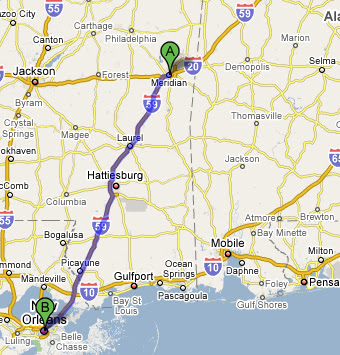
The forests became more and more dominated by pine trees. Alex pointed out that by turning the soil acidic by dropping needles, pines both encourage the survival of their own species and crowd out others that aren’t so fond of the acidity. I-59 was two lanes each way all the way to I-10 and usually featured a concrete roadway. These seem to be much more common down south than up north; there must be others, but the only ones I can remember now are I-95 in northern
I feel a surge of excitement while merging onto I-10, which deserves a geeky title like “
Most likely, we were both insulated from the worst areas and also not up to date on how much rebuilding has occurred. Except for driving to and from I-10, we stuck to Vieux Carre and the nearby Garden District. Certainly, there were signs that things were still not back to 100%--notices about newly expanded hours at many establishments, the occasional gutted building, and a number of for sale/lease signs even in lively parts of town. The roads seemed a little unnaturally empty, making for surprisingly easy driving despite a confusing street layout which had consecutive one-ways going in the same direction on at least a few occasions. Not nearly as bad as
Overall, though, I wouldn’t have found most of the effects unusual without knowing about Katrina. There were plenty of street performers, open shops, and tourists around. We enjoyed browsing a used book store with a friendly proprietor, relaxing while gazing up at Gen. Andrew Jackson, and just walking up and down past all the open doors.
And dinner! Good god it was amazing. We ate at what seemed to be a touristy-but-good restaurant, the kind of place I’d recommend to advice-seeking miniature golfers. There was a stage and the promise of nightly “Cajun bands” but we were too early for any of that. When we left around 6:00, the place was still maybe 15% full. I got a grilled seafood platter—catfish, crawfish, shrimp, and stuffed crab, as well as jambalaya and potato, and everything was just incredible. “One of the best meals I’ve ever had,” I’ll happily say to Grandma and casual acquaintances and the like.
Tuesday 3/11

Location: Gatlinburg to
Weather: Sunny, low 60s
Music: Pigeon John - …And the Summertime Pool Party, Peeping Tom – Peeping Tom, Radiohead – In Rainbows, Sunny Day Real Estate – The Rising Tide, The Shins – Chutes Too Narrow, Porcupine Tree – Stupid Dream, Beck – Guero, Deeper Shades of House
One ongoing traveling dilemma is how to deal with things that are “touristy”. One instinct, easily drawn from having grown up in a summer resort, is “touristy things are bad! You pay too much and/or miss out on the real essence of a place!” Another, sometimes stronger, is “Um, you ARE a tourist, and it’s laughable to try to pretend otherwise. Some of your favorite things to do back home are very touristy; would you tell people not to go to the beach or walk the
Wait, all that about where we went for breakfast? Maybe the mantra should be “don’t take things too seriously.” Nervous laughter…
Anyway, we ended up at the Flapjack’s Pancake Cabin across from our trusty lavender Super 8 for breakfast, not fully aware that it was actually a chain. There’s no moral here; the pancakes were good, my omelet was pretty tasty, Alex thought it was a little pricey, AND IT WAS JUST BREAKFAST. WHY ARE YOU STILL TALKING ABOUT THIS?
150 miles later, we were at the International Towing and Recovery Hall of Fame and Museum. This was an easy one—irony galore and legitimate interest! Learning about offbeat stuff is fun, but what’s really great is getting insight into why people really care about things. I’m certainly not ashamed of not having anything in my life that I care about enough to develop a museum around, but it sure is great that other people do.
We barely paused to glance at the names and photographs of the members of the Hall of Fame, but the short clip of “average Joe tower” talking about how the Hall is “something to aspire towards” during the introductory video really stuck with me. OK, yes, it’s funny that there’s a tow truck hall of fame. But, again, what hall of fame do you get to shoot for? Oh, you’re trying to save the world—who needs halls of fame? Fine, fine, fine…
All that aside, it was fun to see one wrecker with a grille as tall as me and another that went 107 MPH while reading the stories of the people who drove them. Ignoring any analysis of what it means for people to care enough about recovery to compile large collections of toy tow trucks, they were still neat to look at. We left with a t-shirt each and I now finally own a shot glass. Ironic, sure, but also just cool.
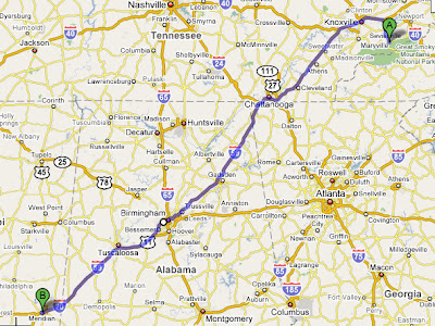
Everyone’s less flustered when Alex drives and I look at maps, but we were reversed heading into
We spent a couple of sober hours at the Birmingham Civil Rights Institute. I thought back to Urooj saying how much “minorities” appreciate when white males come to cultural events, but also that they tend to count how many show up. There was no reason to feel that at the Institute since it’s a well-known and recognized “tourist destination” beyond just being an interesting place to go. Still, whether due to the high concentration of Blacks in the city streets and institute staff, my general unfamiliarity with the south and artificially low expectations of it coming in, or to uncertainty as to my role in society, I had a hard time getting comfortable. Of course, maybe that’s what’s supposed to happen. In high school, the complete lack of diversity didn’t seem like a big deal but now I’m left still trying to catch up.
I kept thinking about what to say if someone asked “What are you learning here?” and couldn’t come up with anything beyond blurting out something trite “Wow, they really went through a lot!” or artificially subdued. “If there’s one thing I’ve learned at four years at Swarthmore,” I thought, “it’s that some of the things that I thought were over really aren’t over after all. And then there’s the politics of a city like
All of the area eateries seemed to be lunch only, but eventually we found a Quizno’s in the storm and left feeling great. I had been dying to see Vulcan Park, home of the world’s largest statue, great views of the city, and a “celebration of Birmingham’s past, present, and hope for the future” or something or another, and not surprisingly it was somewhat underwhelming. It wasn’t the offbeat, somewhat quirky place I’d hoped for but instead fronted by a massive parking lot and playing host to at least one giant, well-dressed group. After viewing Vulcan from afar, we both were immediately turned off by the $3 admission fee; it’s good to share obsessions.
Along the way, we realized that we’d get more time inSunday, March 16, 2008
Monday 3/10

Location: Gatlinburg to Newfound Gap to Pigeon Forge to Gatlinburg
Weather: Mostly sunny, 50s
The more things change, the more they…don’t stay the same.
The mileage/distance profile of the hike to
After another indecisive morning (should I wake Alex up? Get in the shower? Turn the lights on and let them decide? Why not just lie in bed and relax?), plastic-bowl raisin brain, and a quick stop at the visitor center, we were up to 3,700 feet and one of three cars in a large parking lot at about 10:00. I was minorly freaking out about setting off in pants that weren’t wind- or poly- or any other sufficient buzzword. As important as safety is, I also definitely take some pride in walking the walk, or at least so far as it allows me to talk the talk. Passing 20-30 people in jeans and sneakers on the way down, even if they were only heading to the halfway point, kind of put things into perspective.
We eased into things with a nearly level walk along a babbling brook, complete with scattered hemlocks and lots and lots of what I thought were rhododendrons, but were apparently actually magnolias. So far, so familiar; the first inkling that we weren’t at home was the first bridged water crossing. Instead of a bridge made up of slats laid parallel to the water, we had one long, narrow log covered with concrete and a handrail on one side. The concrete was a nice touch, since wet wood can be really slippery, though the handrail was a little too necessary.
More strikingly, we definitely weren’t in
The grade slowly increased as we cruised past the bluffs that give the trail its name about halfway to the summit. Oddly, there was a strong sulfuric smell (from the alum) on the way down but not on the way up. Leaving the car, we had been unsure about how far we would be able to get but, having made good time to this point, we had no trouble deciding to continue on.
We took our first serious break a little later as Alex turned a post-it note into moleskin for a nasty blister. “What a trooper!” I thought. I was in the new winter boots and was fortunate to escape with just a small unpopped blister on one toe. The moderate grade continued through increasingly icy conditions; as self-appointed trip leader I tried to err on the side of “Are you sure you’re comfortable?” and was fortunate not to get eye-rolls in reply.
My favorite part of the day came after we reached the top of a ridge and the trail flattened out for the penultimate approach. The trees—mostly spruce—thickened on both sides and their needles formed an arch over the trail, which was now covered with a few inches of snow. Usually, I read trip reports that make claims like “it was like being in a cathedral!” with some skepticism, but this really was a spiritual experience. I was so thrilled just to be alive.
The spell was broken by the sight of the summit area lodge and a nervous passing of two other hikers at a trail junction (why didn’t I pack those damn pants?) Not knowing which of the several trails led to the true summit, we wandered around for a while before finding a nice-looking cairn in the woods and retreating for a quiet lunch at a nice outlook across the pass. We were still well below treeline, so the air was still and serene.
The view was simply mountains beyond mountains beyond mountains. It was kind of refreshing to just sit and bask without worrying about trying to figure out what was what. All in all, given the large differences in attractions (no arches or alum caves in NH), trail maintenance (bridges & handrails) and views (no treeline, general woodedness), the hiking experience in the Smokies was distinctly different from the Whites. I’m really glad to have tried and enjoyed somewhere else so much. After days of reflective travel, the trip down went by refreshing quickly as we traded roleplaying stories.
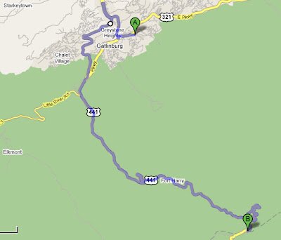
After all the worrying about turnaround times and mountain sunsets, we were back to the car by 3:30 and had plenty of time to drive up to the highpoint of US-441 (Newfound gap, 50xx feet), coast back to town, and shower up before dinner. We hemmed and hawed about where to go to dinner before ending up at a chain Italian place in the Macaroni Grill style; the food was great so we definitely won that one.
One great thing about this sort of trip is that you really do learn about other people and yourself. This most obviously happens, because of the out-of-character responses generated, with respect to quirks and pet peeves. So far, we’ve implicitly established that Alex hates ATM and parking fees and paying too much for meals, while I hate asking for directions and talking to strangers.
We were plowing through our chicken, garlic, and bowtie pasta and got to talking about the hike when I found that I just had to insert a “Yeah, and I was really impressed with how you kept going with that blister! You should give yourself a hearty pat on the back!” or something. “Uh-oh,” I thought and quickly tried to verbalize into a joke, “I’m turning into my dad” as past comments on bowling follow-throughs, test preparation, (of course) hiking accomplishments and most anything else flashed uncomfortably. Looking back, I guess dads are supposed to say stuff like that; maybe I should just work on stopping being so mildly conceited about stuff without dragging psychobabble into the mix.
Traveling with someone you don’t know incredibly well is hard! I know Alex as well as I know all but a handful of people, and still often have a hard time knowing when he’s happy with what we’re doing or is just tagging along. “You know, we can go into some of these shops if you want,” I hastened to remark as we strolled up and down Gatlinburg after dinner. Two days later, I got a little satisfaction out of being asked “Is this okay?” numerous times in
Sunday 3/9

Location:
Weather: Sunny, high 40s
Music: Frank Zappa – Sheik Yerbouti, Porcupine Tree – The Sky Moves Sideways, King Crimson – Discipline, Liquid Tension Experiment – LTE I, Primus – Antipop, Netmusique – International Free Riding Radio Show, Pink Martini, Smashing Pumpkins – Greatest Hits, The Pixies – Doolittle, The Office (Season 4), R.E.M. – Green
Prior to the trip, I had done a lot of planning in the sense of “looking at the map and finding possible ways to go / things to do” but had hardly come up with an exhaustive list. For today, I had seen us heading west to I-81 and taking that nearly all the way with a stop at
Forgot to pack: toothpaste, wind pants, long johns, ibuprofen.