Monday, July 18, 2011

KCMO - Friday

Last weekend, I joined Alicia in Kansas City for Megan Schuster and Adrian (Adi) Vasile's wedding. Megan and Alicia were great friends, often as roommates, throughout college and have maintained an easy, close friendship since then. Alicia was thrilled to be Maid of Honor and I was a happy hanger-on.

Alicia planned for months, pulling off parties and puffballs and surviving a flip-flop crisis. I did little ahead of the night before my flight, when I rounded up various destinations on a not-to-scale map.


It got away from me a bit as there kept being more places to mark, but it did the job. Still, I plotted a trip to AAA (opens at 8:30) in Portsmouth just ahead of the bus to Logan (which left at 9:00). I love when things like that work out.

Friday got underway with Juke Box Hero, a Rock Band classic. I took it as a good omen. After skulking around the sketchy parking lot by the closed movie theater and trading in the originally-proffered map of Kentucky, I comfortably made the bus with state and city maps in hand.

C&J Trailways has always been a tough one for me. Pristine, but expensive. Convenient, but scheduled. It beats paying Logan parking prices, but ultimately I'd prefer a lower-frills / lower-cost option. This time, I did enjoy the ever-looping black-and-white TV episodes, eventually realizing that it was that weird Addams Family show that used to come on before Saturday morning bowling. Now, I can't get enough of that John Astin grin.

At the airport, I finally had time to sit in one of the sweet rocking chairs.


The view was pretty nice. As always, I wondered who bothers to stay at a Hyatt this close to the airport.


We were lucky. Discount carrier Frontier Airlines flies only two routes to New England, but one is a Boston<-->Kansas City direct. A three-hour flight for under $100 - not too shabby. With such a small presence, Frontier has a gate-sharing arrangement with US Airways Express. They used equipment that I thought carried a long-defunct brand, but I was mixing up Midwest with Eastern Airlines. Midwest also no longer exists, but did until very recently; they were merged with Frontier under the latter name. I later found out that the warm cookie presented as a Frontier trademark was actually stolen from Midwest and has a rich history.

I thought I was flying to MCI, but the airport marketed itself as KCI. Understandable, but the official explanation is pretty weak - call us KCI, even though it's not a legal airport name. Not many cities start with the disallowed letters of K, N, or W, but note that Newark, for example, is stuck with EWR. Whatever the letters, I was in the city of fountains!


I grinned, remembering Bill James's 1986 essay about how his home city suffered from its insecurities, obsessively comparing itself with luminaries such as Rome and New York and always looking silly as it came up lacking. He compared this to the sad saga of the Kansas City Athletics, who made a number of suspicious trades with the New York Yankees en route to recording 0 winning seasons in 13 tries during their time in KC.

MCI Terminal C was air-conditioned to the point of chilliness, I waspishly noted the energy overuse. I ate my words a bit after stepping outside. It was mid-90s and very humid all weekend, barely reaching 80 at night. Highly unpleasant, to be sure, but it's easy to overstate the unpleasantness - it was comfortable unless you stayed out in the sun long enough to start sweating.

I get to be a member of National's "Emerald Club" through work and was genuinely pretty excited about having my pick of the "Emerald Aisle". Last time, I got a sweet Chrysler 300! This time, the pickings were slimmer but I was pleased to have a chance to drive a Jetta, what with all their clever advertising over the years.


The instrumentation was slick, but the acceleration was odd, with a gap between hitting the gas and getting sound or RPMs from the engine. Also, it had small side mirrors and my pet peeve of flimsy, small sun visors. I'll pass, but thanks.

There were clear stations all over the FM dial, but (not surprisingly) most were country, conservative talk, or religious. Fortunately, I soon settled into a blues show on KKFI. The excellent Friday Night Fish Fry was a standout. I love to party!

My prior trip across Kansas City, last September, featured tornado warnings and very real thunderstorms. This one was a lot more peaceful, even at rush hour. Nothing slow until some lane closures on I-70 east of town, and even that wasn't too bad. Getting to drive under a cable-stayed bridge similar to Boston's gorgeous Zakim Bridge had me grinning widely.


KC has a pretty clean grid which continues into Independence despite the interruptions of I-435, train tracks, and a waterway.


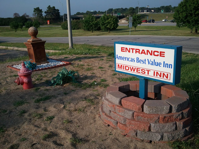
The grid made it very easy to find Megan's mom's house. I was pleasantly surprised and relieved at being able to exchange warm greetings with everyone; it had been a while. After we prepared the girls' night entertainment, I checked into my trusty (twice in a year - yeah, we're going with "trusty") America's Best Value Inn one city east in Blue Springs.


The rehearsal dinner was in downtown Independence; I passed a number of near-mansions on South Main along the way. Downtown seemed odd; it was a bit quiet, but I think what got me was the lack of any tall buildings. I'm not sure any were over two stories. At home, many small cities have old mill buildings or are tourist towns with hotels that are, if not huge, at least a few floors high.

Dinner, a BBQ buffet, probably fell short of great but the brisket, pork and all the fixings were more than good enough. We sat with old friend Meg and a high school friend of Megan's named Marla, who was a great conversationalist, knew her field/passion (art) impressively well, pointed me towards a bookstore, and even claimed to have heard of Bill James. As Alicia would say, a great random dinner companion for a guy like me.

We lingered after dinner, talking to Adi's Romanian parents in French with varying degrees of success, and it was dark by the time we left. The moon was full, huge, and yellow; even the motel bright lights could do little against it.


Inside, the AC worked and the Royals got a game-winning homer from Eric Hosmer before I passed out nice and early. It felt good to be back on the road.


Wednesday, July 13, 2011

Pretty Persuasion

I just can't get enough of the title song - mellow songs that pack a punch are so cool!

Some Sporcle quizzes for New Hampshire fans:

Name the state's incorporated cities: http://www.sporcle.com/games/itchynip/nh_cities. This one is a doozy. 10 is a good result, any more means you've studied this before or are a freak.

This one is an amusing sideshow to the above: http://www.sporcle.com/games/hawkeye2/nh_largest_cities. I think the creator just picked off the top 10 cities in population, but it's funny to see Claremont and Lebanon classified as "major" while Somersworth, Berlin, and Franklin are left out. I prefer to think of it as the NH-120 connection running deep.

A hard one, but you'll learn something: http://www.sporcle.com/games/Athena13/the603. For example, I had no idea that "demonym" means "the resident of a locality". Too bad New Hampshire doesn't lend itself to something like "Mainiac"; apparently "New Hampshirite" is the best that can be done. At least it sounds like a rock.

Tuesday, July 12, 2011

A Matter of Time

Going from softball games on Stackpole Rd to The Loft, our postgame haunt, has always been a little annoying.


I guess it doesn't look all that bad on the map, but who wants to take a zig-zag route and have to negotiate Weeks Crossing? Happily, there is now a better solution.


We're making the jump to Satellite View to show that there's a sizable pond just off "Willand" behind Hilltop Fun Center. Who knew? Actually, there are some dirt roads heading in its direction; a truck pulled out of one of them tonight.

Earlier this year, "Willand" was passable, but in terrible condition between Hilltop Fun Center and Penny Lane. Having to dodge holes in the road made it no faster and not even any more fun than going around. The road now has fresh pavement to the Penny Lane intersection and is in great shape.

I've taken this route a few times and have always left High St (NH-9) at the light by Irving at Commercial St. Tonight, another driver showed me a shortcut - just take Penny Lane (it's signed) by KFC / Taco Bell. It could be a tougher left turn if you're coming north. Also, beware of the left turn onto New Rochester Road (NH-108) during busy times. Late evening, when our games end, is not busy; we've done a time trial and Penny / Willand is a hair faster than the default.

I like three things about this route:

1) Random pond
2) Coming from 1o8, it passes by a karate studio and promptly dead-ends (unless you turn right).
3) Who had the chutzpah to suggest the name Penny Lane, anyway?

Happy corner-cutting!

Poll

Giant Dover birds-eye view at the top of the blog: yea or nay?

Monday, July 11, 2011

Another Round

We lost the mountain man to insomnia and got to bed late. But, we're starting to get in hiking shape and had the benefit of the invigoration unique to spending time with a fun new friend. There was a crackle of promise as we took the same route as the prior Saturday, give or take five extra miles at the end.

West Side Rd in Conway and Bartlett may be the prototypical combination main street and back road. What's a better choice?

I have history with Mt. Carrigain. A trip with dad in 2000 was the first where I didn't reach my goal. Looking back, it's easy to come up with good reasons why - two unexpected miles on the closed access road, all heat and no breeze, dad's mistimed stories of heat stroke, common sense. Viscerally, it sucked and I was very satisfied when we successfully summited a year later. Tuffsy and I returned on a bluebird day in 2007 and took a longer ascent route around the base of the mountain and up the back side. A great combination of woods walking, history, and challenge. I was all smiles when Alicia indicated that she was up for the longer walk.

We snagged one of the last spots in the ~30-car lot and played rather stressful leapfrog with a group of determined young men for the first mile and a half before turning right onto the solitude of the Carrigain Notch Trail. We would see only five people over the next 6.6 miles.

I recounted the tale of that 2007 hike - the blocked road to Mt. Jefferson, "settling" for Carrigain, the awesome route, the satisfaction of being able to speak about the area, my 21st birthday party up at the camp in Acton that night, the four more days of fun that followed, and the "90 hours in nine days" (but who's counting) stretch to close out my Wonder Mountain career. The trail generally followed old logging roads through mixed woods with good footing as the masses of Carrigain / Vose Spur and Lowell / Anderson squeezed us into the notch. Alicia aced a few moderately difficult water crossings.

The height-of-land (what a cool word) has boulders, slide views, thick forest, the satisfaction of a completed climb - a wonderfully wild place. Down the other side, we soon entered the Pemigewasset Wilderness; its border follows the ridgeline separating the Saco and Pemigewasset (later, Merrimac) drainages.

Federally-designated Wilderness is controversial as it places great, permanent limits on land use and is mildly riskier for the unaware than garden-variety National Forest. I'm generally a fan since the lower level of trail maintenance helps me feel a little more "in the wild". The boundary signs don't hurt, either.


The challenge of administering Wilderness was soon evident as we came across some removed blazes. Trails in Wilderness are not supposed to be blazed, but how do you deal with blazes that were there prior to the Wilderness designation? The results of removal aren't pretty, but well-applied blazes take many years to fade. It's a knotty issue.


Soon we came across the "Oh yeah!!!" section of Carrigain Notch, where ferns and shrubs line the trail instead of trees. Unusual terrain for the Whites, and thrilling to stroll through.


A while later, we swung left onto an old railroad grade. You could tell it was a railroad grade rather than just a road because the guidebook says so, but also because 2) It was wider, straighter, and on flatter ground than a logging road and 3) It was built up into a real road more so than any logging road. Visible old railroad ties (not pictured) were only the clincher.


According to the excellent J.E. Henry's Logging Railroads by Bill Gove - one of two authoritative books (C. Francis Belcher's Logging Railroads of the White Mountains is the other) on the logging history of the region, the region was logged from 1907-1910. So, while recovery was gradual and many fires followed until the leftover slash was depleted, some of the trees in the area probably recently celebrated their 100th birthdays. And many more!


The East Branch and Lincoln logging railroad was the main line in what's now the Pemi Wilderness. We passed near the former Camp 20 - just scratching the area's northeastern surface.


Some elevation gain was long overdue and eventually we turned left off the railroad grade and into the mountain. Another layer of the area's history is Mt. Carrigan's use as a fire lookout tower. In the heart of the White Mountains, a watcher could spot a blaze on nearly any of the region's notable peaks and plenty of its valleys. The tower has been decommissioned for old telephone wire that served the tower is still visible at times next to the Desolation Trail.


The tower was built in 1910. I can't find a decommission date, but many similar towers stopped being used in the 1960s due to the increasing use of air surveillance by helicopter. Use of choppers has since declined, but funding for towers, while somewhat stable, has never come back in vogue. Some are still staffed by dedicated but aging volunteers. There's a fantastic memorial near the tower on Mt. Agamenticus to those who have staffed it and two other southern Maine towers.

I just said that the climb could no longer be avoided, but we sort of did - a 1.3-mile deficit deal, so to speak, but finally it was time to pay up.


It quickly got less steep over time and we were well warmed-up, so it wasn't too bad. A spirit-raising encounter near the top helped, too.

Wide-eyed woman: [Distant laughter]
WEW: [Loud laughter]
Handsome white dog: [Walks up to us]
WEW: "Whoa! There are some people coming up!"
Me: "We haven't seen anyone in a while!"
WEW: "We didn't think there'd be anybody on this trail!"
Me: "There was one threesome, they were going to turn around..."
WEW: "NO DON'T TURN AROUND!!! You're almost there!"
Alicia: "Oh no we're not turning around, that was them."
WEW: "OHHHHHH okay!"
WEW's companion: [Chuckles]
Me: "Haha yeah....well, you're in for a treat..."
[Euphoric LOVEFEST about Carrigain NOTCH and FERNS]
HWD: "Woof woof!"

At the summit, we touched up at the survey marker and climbed the tower. It was rebuilt for view-seekers after the firewatcher's cabin was taken down. The views spanned mountain scenery,


civilization,


and popular culture.


We spent quality time both atop the tower and on the less-windy summit rocks. There was nothing to do but be content.


Eventually, we said goodbye to the Pemi.


Early in the descent, we caught one more glimpse of the tower.


The descent was rocky and went on a bit longer than it needed to. My trooper companion endured the piece of glass in her foot without complaint, and there were some bright spots.


Back at the car, we stayed on last Saturday's course, including the Milton Mills back way, all the way to salmon and veggies at Jim's with my mom. Not even being pulled over for a burnt-out headlight on the way back to Dover could dampen our spirits. Okay, maybe for a little while. But, after two years of too much talking and not enough hiking, it felt great to relearn why I always say I love it so much.

Wait, a sappy sum-up and we didn't even mention the abandoned logging village of Livermore? Oh man, oh man...

Tuesday, July 5, 2011

Everybody Knows This Is Nowhere

We conked out around 7 on Sunday night so Monday started as the best of both worlds: early and well-rested. It promised to be a scorcher, so we hastened through some much-needed cleaning before the sun warmed things up too much. Our apartment gets a ton of sun and thus very hot; hopefully in another few years, if we're somewhere similar, I'll be over myself enough to just get the damn AC unit. Soon, we headed down to the water, hoping for some breeze.

I commute over the Little Bay Bridge and watched with interest through the early spring as the bridge it replaced, the General Sullivan, was worked on through the winter and early spring. Cranes shifted by the every few days and spindly new paths grew towards landfall in Newington and Dover.

Why? The work actually had nothing to do with non-motorized traffic - which was temporarily left without a link between Newington and Dover -and everything to do with the Little Bay Bridge Expansion. Believe it or not, there's room to fit a new four-lane span between the two current bridges. Construction of the center span requires the space used by the former General Sullivan approaches, so new approaches needed to be built off to the side. The center span construction will last well into 2013 and promises to be interesting.

Already, machinery is starting to be put in place to build the new span. The Hilton Drive underpass of the Little Bay Bridge, connecting the two sides of Dover Point and Hilton Park, will probably remain closed for a couple of years.


The roadway on the bridge is vaguely reminiscent of The Road, but that world was never this sunny. I have a memory of driving across the bridge, but it closed in 1984 so it's a false recollection.


Great Bay was full of boaters; a few struggled with the stronger-than-ever tides but most powered through with incident, some with a little help from a larger friend.


There were a mildly unnerving pair of signs on the Newington side, even though the section wasn't close to capacity.


There was a nice breeze on the bridge, and it was fun to watch the cars and boats, so we hung out until it was time for Alicia to go to work. On the way out, I noticed an old sign - a relic of the days when the Spaulding Turnpike was at times un-numbered and NH-16 was the local alternative (today's Dover Point Rd, for instance) between Newington and Rochester. I noticed on my way home from work today that there is at least one similar sign east of the highway in Newington, but there must not be many more.


I can't find a date for when the numbering switched, but I think it was sometime in the early 1990s. There was a ripple effect: NH-125 was extended northwards from Rochester to northern Milton to replace the old 16, NH-108 was extended from its intersection with Dover Point Rd through Dover and Somersworth, all the way to Rt 125 in Rochester. Dover Point Rd lost its state highway designation, and Old Rochester Rd ceased to be NH-16B. I think Rt. 33 was modified as well.

Today, the NH-16 vs. Spaulding Turnpike lives on for one brief stretch: ramps to / from I-95. This is visible both north- and southbound, but is most obvious southbound, where Rt. 16 is signed as leading to the traffic circle and the Spaulding takes you to the interstate. My guess is that this is to establish unique names for 911 caller location.

After Alicia left, I spent some more time in the relative cool of the park, picked up CSA veggies, and eventually joined the crowd at Henry Law Park for the Dover Independence Day celebration. The band, Locksley, played pretty good pop songs with nice vocal harmonies but seemed to struggle to find energy; the crowd was understandably more there to have fun with family & friends than for the show. A medley of "Last Night" and "American Girl" stood out for being a cool and unique similar-songs connection. I got a good start on a promising book before it got too dark to read and fireworks from all around served as taps for the holiday weekend.


Underwater

On Sunday, I woke up around 6:00 but shut my eyes for a catnap. When I opened them again, it was 8:41. Oops. Better today than a work day, I grumbled to myself and tried to shake off a disturbing dream. A shower later, I struggled to set a "we might only have time for one peak" expectation without turning terse and abrupt. Although Alicia's robust enthusiasm helped get me out of my own head a bit, the gray clouds overhead were still a decent match for my mood as we got underway.

The route matched the prior day's to West Ossipee, where we turned west onto NH-25, then north onto NH-113. This is an area with both windy old routes and modern state highway designations that jump from road to road; a sign points you to the left or right to stay on the state road while a local road continues straight ahead. With Waterville Valley and Sandwich Notch restricting access on the north and west, and highways 16 and 25 bounding things on the south and east, the state highways in the Tamworth / Sandwich area (113 and 113A - particularly the latter) have to curve all over the place to get anywhere at all. If you lose the thread (easy to do), you pretty much need local knowledge or a compass to find your way back.


Our route to the trailhead is marked and was easier than expected. Turning onto NH-113A, I was very pleasantly surprised to see that we were on the Chinook Trail. The picture of the dog was indeed on the road sign. A very cool image, and it solves the mystery of the existence of the now-closed Chinook Cafe (which featured an image of the same dog on its sign) in Conway village.

One of the great things about the White Mountain region - and rural life in general - is the sort of local heroes that always seem to emerge. Real renaissance men and women, usually with feats of physical strength or endurance that set them apart from similarly notable city folk. Arthur Walden, husky trainer (Chinook was his best dog, a real legend) and his wife Katherine Sleeper Walden were two such individuals. Today, they are remembered in the best ways one can be in this region - with trails (the Walden Trail up Mt. Passaconway, the Sleeper Trail) and mountains (East and West Sleeper) named for them.

I suppose most rural heroes probably lacked some of the people skills that helped Really Famous People become so well-known; I guess I value such skills less than the self-motivation required to do so much for the public good in relative obscurity.

The sky had started to spit as we arrived at the trailhead, so we bagged Mt. Whiteface and its open ledges in favor of the more wooded Mt. Passaconaway. It'd be about a 9-mile round trip with a little under 3,000 feet of elevation gain - a nice moderate day.

The Dicey's Mill trail is mostly flat for its first couple of miles, doing little to prove that today's housing / forest line is naturally mandated. Indeed, a river crossing about two miles in is near the site of a 19th-century sawmill (no visible remnants). Across the river, the path steepens but remains straight with a near-constant grade; the usual marks of a logging road. Probably the whole mountain, or close to it, could have been logged without too much trouble.

High and low clouds combined for a dreary day, but we maintained a good pace and got into the physical side of the hike. Eventually, we climbed to some interesting between-the-clouds views, although you can barely tell from this photo.


There are usually a few steep, wet rocks on even the kindest trails, but we passed without incident. A moose or two had made it as well.


Soon, we reached a SW outlook - the best view of the day.


After tagging the viewless summit and a lunch break, we started down. The rain, which had mostly held off, intensified before long. It was a loud, but not all that wet trip down; the thick canopy kept most of the rain off. Along with the ol' "raincoat over the backpack" trick, my stuff stayed pretty dry, helping the trip squeak out "rainy adventure" over "big bummer".

Alicia really found her stride on the descent and we were quickly back at the car. It wasn't the right day for the Sandwich Creamery, but we'll be back - and delicious nachos featuring leftover chicken from Friday and 12 (!!) hours of sleep were worthy post-hike indulgences.

The next morning, I got a huge kick out of the current issue of the Wonalancet Out Door Club (WODC - the area's trail-maintenance organization) newsletter. Part of the joy of reading about rural heroes is that those who write about them tend to share common stylistic preferences - dutiful research, understated prose, occasional rambling, and a fiendishly clever word here and there. Like a small town, it appears languid until proper attention is paid. Then it becomes quaintly fascinating, with interest leaping and bounding past what's merited. Finally, it levels off; where it does so depends on the reader, and may as well be a mark of his or her urban vs. rural preferences.

Or, the last may remain unclear. A favorite passage: (the author is uncredited, but may be editor Susan Goldhor; the subject is Dave Bowles)

"And here we’d like to insert a little digression into snowmobilers and hikers/skiers. Dave has been an avid snowmobiler (as well as hiker and skier) for a long time, and many hikers and skiers have a knee jerk negative response to snowmobilers. But there are snowmobilers and snowmobilers, and Dave is clear in his response to the overpowered speeders we see too often today; some of whom he’s had to rescue after they misjudged a curve or sped into trees. For a long time, Dave’s machine of choice was a Motor-Ski Zephyr (now regarded as a vintage classic); a motor perched on skis, and a body pretty much amounting to a front fender with headlights, that he took everywhere at a average speed of ten to fifteen miles per hour. He speaks fondly of going up to the ridge between Paugus and Chocorua with a few other snowmobilers, and just sitting there and enjoying the view. It was the old way to snowmobile -- on little machines, going slow, brushing out the trail, building bridges where needed, and enjoying the woods and the view."

The Honda was up to about 500 miles for Friday - Sunday; staying close to home on the 4th was indicated.

Monday, July 4, 2011

The Enemy Within

On Saturday, I drove to Bartlett to help Meredith (my step-sister) and her husband Colin move into their new digs.

I'm a big believer in making hay while the sun shines, but I wilt on hot summer days. So, I love getting an early start and enjoying some quality hours before the humidity sets in; this day was no exception. One drawback to going from South Berwick to Dover is the loss of options for heading north. Rather than being able to willfully spurn the highway by taking Rochester / Salmon Falls Rd (boy, do I wish I had a picture of the old 'Rochetser' Rd sign), any route but due north on the Spaulding looks pretty silly. Well, I guess it's nice to not suffer the embarrassment of taking yet another wrong turn in downtown Berwick.

Admitted, highway speeds on a gorgeous day with the windows down aren't anything to complain about anyway. The house is across the Saco River and up the side of Cave Mountain from the main drag. It was neat to see actual residences in the town (there is very little housing, or anything else for that matter, on 302). Dad speculated that the older houses near the river were formerly for railroad employees; the line is very close the river near the center of town. These days, the Conway Scenic Railroad runs a tourist train up to Crawford Notch a few times a week. In its heyday, though, it was part of the Portland to Ogdensburg Line. There is a video about getting the line through Crawford Notch (requiring several great feats of engineering) at the Portsmouth library that looks totally awesome. Shockingly, the line was never built to Ogdensburg as chartered, perhaps because of an exchange like this:

Railroad middle management: "Hey, the knowledge that our industry is badly overbuilt is hitting us like a speeding locomotive.
Railroad upper management: "Tee-hee."
RMM: "So, do we still have funding for the line from Lake Champlain to Ogdensburg?"
RUM: "Sure, sure. Just one question."
RMM: "Shoot."
RUM: "Where's Ogdensburg?"
RMM: "Not sure. Oh, I see what you did there."

Later...

RMM: "So, looks like the plans to extend our Portland - Vermont train to Ogdensburg have been derailed."
Railroad lower management: [Guffaw].
RMM: "Can it. Anyway, inform the men."
RLM: "Actually, customers have been transferring themselves to the Ogdensburg and Lake Champlain for years - that is, the few of them who actually want to go to Ogdensburg. Say, where is that place, anyway?"

The world survived without one more line towards Ottawa.

Back in the present, the list of work to be done on the just-four-years-old house shook, but did not topple, my excitement about eventual home ownership. The work was quicker than expected, I got a good sweat in, and soon we were enjoying delicious pizza flatbreads with a mountain view.

Sunday's plans were cancelled due to lack of lumber, so I moseyed on south in the late afternoon. I started out with Bear Notch Rd - seasonally closed, but well-paved and suitable for driving fast. It was especially sweet with the deciduous trees forming a gorgeous green canopy and since I hadn't been on it since finding moose with ABenn almost five years ago.

I was sandwiched between two groups of motorcyclists and quickly noticed the first ones following a pattern; whenever they passed other riders, they'd take their left hands off the handlebars and stick them out, slightly angled downwards. The riders coming the other way would usually do the same. It made me feel great! I'd love to have unconditional waves coming my way. I actually got my motorcycle permit a few years ago and rode a bit on Jim's scooter, but I can't see "buy a motorcycle" leapfrogging "save for a house" anytime soon.

A bit of googling turns up many sites with similar explanations of this phenomenon (a sign of community, though with some variations to mark one's place in the herd); I have to link with the one with a Rush lyric in its title.

The change of plans allowed me to stop by a party at Jim's back home in Wells and, just as importantly, to take the back way to Milton Mills (in reverse).


That's not nearly enough granularity - in sections:


The last stretch into downtown NB (and whatever is chosen to get back to Wells) is omitted; you get the idea.

Historically, we only went this way on hike days or (rarely) other White Mountain trips. This mean that I was usually peacefully half-awake and headed for an awesome day. What wasn't to love? After learning to drive myself, I continued to use it for hike trips or sometimes when heading to Ann's (now also my Dad's) house, but much less since moving away from Wells.

Here are some of the reasons I love this route:

1) It's remarkably direct

Apart from the jog over to the highway, the route is nearly as straight as an arrow. You're on Lebanon Rd, then Milton Mills Rd. They just feel like the roads you are meant to take.

2) It's fast

Most of Lebanon and Little River Rds through North Berwick are 45 mph. That's as good as it gets for a non-state-highway in Maine.

3) Five Corners

Coming from North Berwick, the route gets off to a great start with a five-way intersection with Old Sanford Rd (there signed as Governor Goodwin Rd) and the 5th wheel, Turkey St.

4) Make Way for Ducklings

Once, Emily and I had to stop while a mother duck and her flock strode primly across Little River Rd.

5) Bailout Route

In 2005, the first time I got confused by the worst signage ever coming into downtown Berwick on Rochester Rd (you're basically told to turn left on Pine Hill Rd to get to Wells), I kept going the wrong way all the way to Little River Rd before this route got me home safely. My mistake for not turning around far sooner, but it was sure was good to see a familiar sign.

6) The deer

When I was young, we always looked for the deer who lived in a pen in the front yard of a house in Acton at the bottom of the hill. Ironically, a child growing up at that house at that time later became one of the Acton kids at Wells High and eventually one of my best friends.

7) Lebanon speed trap

The area around the Bakers Grant Rd intersection in Lebanon is marked as 25 mph. Strong stuff given that there's almost nothing (one restaurant) in the area and Lebanon didn't even have its own police force for a while. Still, I always slow down, just in case....

As an aside, in 2007 I discovered the Emery Mills Rd back way to a different part of Acton. This takes you across Bakers Grant Rd a bit to the east. I was excited to avoid a 25-mph section....zounds, there's one out here, too!

8) Foxes Ridge

Tbe long hill in the Acton section of the road offers a test for your engine, great views into the foothills (a portent of what's to come), and an awesome name for a road. What's not to love?

9) Milton Mills

This tiny village is incredibly quaint (and probably very poor) as the namesake mills (and shoe factories) are long gone. Still, the library building is nice and the village is a distinctive landmark on the route.

10) The cemeteries

I hadn't really noticed these until this Saturday, but boy there are a ton of tiny cemeteries on this route. Somewhere in the 10-15 range. I'm sure there's tons to be learned about who used to live in the area; probably many of their descendants are still nearby today. They also reaffirm the route's status as the "main line" between its two endpoints.

That's a nice round number, so we won't bother getting into the scattered businesses on Little River Rd, how you bust out of the wilderness onto Rt. 16, and how the route provided me with the coolest way to Mayocraze 2004.

Once in Wells, I made a quick detour over to Perry Oliver Rd to verify the location of the CMP / gas line right-of-way; it was where it was supposed to be.

Jim made steaks (what a food day it was) and then a huge bonfire (helped by copious pre-pouring of gasoline), I survived baggo with the cool kids, and made it home to Dover before Alicia arrived with reports of huge crowds in Portsmouth. A great holiday weekend day.

Saturday, July 2, 2011

Announcement

Since today I got to drive among the many very green trees on Bear Notch Rd in Barlett (more on that later) and talk about the Yellowstone-->Salt Lake City drive last fall where I played it incessantly, it seems like a good time to declare Neil Young's "Big Green Country" to be the official song of this blog.

I don't love this live version but I can't find the studio one anywhere online.


In Through the Out Door

On Friday, we got a solid B at navigating Massachusetts State Highway 60 en route to Arlington, MA.

More importantly, the lovely Alicia was linked to on noted craft blog One Pretty Thing. If you're a craft blogger, take the survey!

Whichever weekend is closest to July 4th has long been the unofficial start to "summer" - tourist season, really - on the Seacoast. Still, I was shocked to see cars backed up from Portsmouth more or less down to the Mass. state line. The next barrier northbound is the Maine Turnpike barrier toll that must be 7-8 miles into Maine and God forbid...well, maybe there was an accident. It was kind of amusing to see cars stopped in the high-speed toll lanes in Hampton; I believe the cool kids would call it a "fail".

I-93 in the Medford ("Meffa") area is under ongoing construction this summer. It's already steered me towards the dreaded Route 1 Sonic-->Kappy's stretch once and could have forced us to go all the way around to Route 2. Admittedly, this is the way I'd always gone before after receiving a dire warning about the local roads between Medford and Arlington being hard to follow. But, it's a new summer and I'm freaking trip-blocking these days, for heaven's sake, so the more direct route was indicated.


Note that the marked stretch of Route 60 has several jogs. More on those later.

All was well - great, even - up to exiting Route 93. Not even a backup or tense moment at the weave lane. The northbound traffic wasn't even that bad - I suspect that some folks have made a habit of avoiding the road this summer to the benefit of schedule-checkers.

Our destination in Arlington was only 3.7 miles from the highway on MA-60, but the road manages to pack in four messy intersections and three rotaries into that space. Now, I've always heard that there are a zillion rotaries in Massachusetts and have certainly come across quite a few, particularly on the Cape and en route to the airport. But this was something else entirely - particularly the back-back rotaries on both sides of the Mystic River.


Also, note that both cross-streets are labeled as the Mystic Valley Parkway. Yeah, that's not confusing at all.

We actually made it through those without incident since our rote was fairly straightforward. It was back in Medford at Winthrop Square where we got off-track.


Odd angles and a random extra street...bad news. Not surprisingly, we ended up on 38 but found our way back to 60 on side streets with the help of Delorme's wide definition of what belongs in a Boston city zoom-in map.

After arrival, we had a wonderful night at Meredith's house with her and Chris. We were all friends together throughout college, but I've talked to each one about the other quite a bit over the years, so to see them both together was especially nice. Not to mention that they are both great, great people who I wish I saw far more often. We (those two plus Alicia, mostly) made a delicious dinner spread, drank delicious gin + lemonades, and enjoyed a very very awesome half-hour on Spy Pond in borrowed canoes.


We drove Chris home to Allston on a route that was as much if not more dizzying than the route to Arlington, but I was taking directions rather than really driving and one dissection of rotary minutia per post is enough. I did take pleasure from Chris enjoying a couple of selections from the mix CD I've been overplaying recently.


Later, as I conveniently took the opportunity let the CD continue playing, Alicia (who's had to hear it a few times, now) declared that it did have a theme, and that the theme was "overwrought male voices". I countered by saying the voices were "just wrought enough".

Overwrought or just wrought enough? You make the call. By the way, the real theme is "rock songs I've always loved but have never heard very often...plus a few extra songs to fill out the CD."

It was a beautiful night for Storrow Drive, and although northbound traffic on US-1 was pretty heavy for almost-midnight, it wasn't anything serious. What a great Friday!