Tuesday, March 18, 2008

Monday 3/17


Weather: Partly cloudy, low 50s
Music: Primus, Hush, Pigeon John

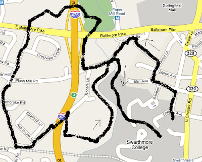
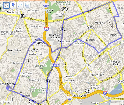
Having finally determined that the roads signed "No outlet" really don't go anywhere, I found Hillborn Road on the first try and, after dodging a surprising number of cars, caught sight of a red fox running into the woods behind a house. A pretty cool way to start the afternoon. Wallingford Road was narrow and crowded as always; I picked my way through edges of lawns and ran across the bridges.

Many people independently know about the Leiper-Smedley Trail, the bike path that runs past those old garden ruins near the Blue Route. I've been on the commonly-traveled section between Plush Mill Road and Avondale Road many times but never the northern end. Where could it go?

Three minutes later, I knew: the trail runs flat to the Baltimore Pike / I-476 interchange with the set-back light that I always almost run, crosses the road, and ends in a small park with a picnic table up on a small rise. A pretty spot, allowing for the 10 lanes of traffic running just a few hundred feet away. A couple of dog-walkers had set up shop so I continued onto a well-defined dirt path heading towards the highway. One trail leading towards the trolley tracks was blocked by two young rough toughs so I turned left towards the freeway.

Andy and Annette memorialized their love in a large oak in 1973, and others had left their mark later in the 70s, all before the Blue Route made this a far less attractive place to hang out. Surprisingly, the trail led right under the highway, the supports of which being completely covered with graffiti. Once across, a couple of man-made bike jumps loomed as the trail turned uphil, and a number of fresh-looking treads made me lower my ipod volume a little.

The Pike broke back into view and we followed it up a fenceline before the fence ended and a side path went over to the pavement. Crossing five lanes of traffic is fun! Memories of running across to route 1 from work for Skin Sandwiches kept the good times rolling as I continued straight across onto Turner Road. This is the road you end up on if take Avondale Road down by the condos and never figure out which road to take over to PA-252. The shoulder was narrow, but the traffic was slow and the walking pleasant. Passed by an entrance to Furness Park, a Nether Providence presentation. Next time...

A number of dead-end left turns into small developments passed before the turn to Rogers Lane, just across from the road to the Wallingford train station. This is the road that comes out on Wallingford Road just W of where the trail through the Crum ends. After passing a gardener and studiously avoiding eye contact, I hung a right onto the southbound section of Leiper-Smedley.

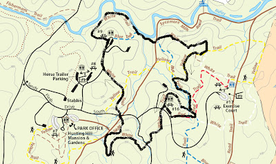
One time, I crossed the Crum going in the other direction and found a trail back to the bike path, but trying to make the return trip didn't go so well. There were beaten paths down to the area by the railroad trestle, but down there was just mud and prickly stuff and no clear place to cross anyway. The only well-defined path led back upstream, but I figured the old crossing point was somewhere nearby so I headed that way. The water must have risen or something, since it never showed, but the path was easy to follow past biology experiments and petroleum pipeline signs. Four white-tailed deer ran up a hill as I blundered near.

Finally, I came out back on Wallingford Road, crossed on the bridge, and was back on the regular trail through the Crum. I was late for dinner and tried to run home, which was a really bad idea.

Wednesday 3/12


Location: Meridian to New Orleans, LA
Weather: Sunny, high 60s
Music: Don Cabellero – World Class Listening Problem, Mission of Burma – onOFFon, Frank Zappa – Hot Rats, Porcupine Tree – In Absentia, R.E.M. – Fables of the Reconstruction

It’s hard to differentiate between meaningful discomfort and mere adjustment time. We sat right next to the kitchen area at my first-ever Waffle House and I didn’t exactly feel at home with all the noise, the matronly supervisor and drawling waitresses, and the camo-wearing and/or smoking clientele. It was easily the most stereotypically Southern experience yet, and I struggled to avoid placing my prefab life stories onto the participants. A day later, though, I also remember that my cheese and eggs were good, that I actually like grits, and would like to go back. So maybe there’s hope after all.

The forests became more and more dominated by pine trees. Alex pointed out that by turning the soil acidic by dropping needles, pines both encourage the survival of their own species and crowd out others that aren’t so fond of the acidity. I-59 was two lanes each way all the way to I-10 and usually featured a concrete roadway. These seem to be much more common down south than up north; there must be others, but the only ones I can remember now are I-95 in northern Maine and on the Pottstown Expressway between Allentown and Reading, PA. We’re joined by US-11, I-59’s sister (or is it brother?) road several times, often for long stretches; it’s as if the interstate planners decided to just expand the existing road and only build a completely new highway around the larger towns. Even when we do go through one of those towns, the highway forest remains unbroken--there aren’t too many people down this way.

I feel a surge of excitement while merging onto I-10, which deserves a geeky title like “America’s floor” or something. As we approach New Orleans, I nervously look for signs of devastation, unsure of how to properly react. Our first clue comes at the twin narrows bridge about 20 miles west of the city, where westbound traffic is down to one lane. In a different place, I might have suggested that we get off and bushwhack, but here we were duty-bound to experience the aftermath. An incredible amount of cranes, long lengths of incomplete bridge, and energetic workers were on the scene, confirming what I’d read about reconstruction occurring at rarely-seen speeds. We failed at lane-jockeying but were on our way after only about a half-hour delay. Even after failing to realize that “Vieux Carre” was the French Quarter, we had no trouble finding a visitor center and parking lot. Both of us had gotten plenty of friendly advice about staying safe in the city and I, at least, probably spent too much time worrying. Of course, it’s hard to say what “too much” is until you’ve seen “not enough”.

Most likely, we were both insulated from the worst areas and also not up to date on how much rebuilding has occurred. Except for driving to and from I-10, we stuck to Vieux Carre and the nearby Garden District. Certainly, there were signs that things were still not back to 100%--notices about newly expanded hours at many establishments, the occasional gutted building, and a number of for sale/lease signs even in lively parts of town. The roads seemed a little unnaturally empty, making for surprisingly easy driving despite a confusing street layout which had consecutive one-ways going in the same direction on at least a few occasions. Not nearly as bad as Boston, though. In a similar vein, Alex seemed mildly surprised at having to pay $12 for seven hours of parking, but I thought it was downright cheap.

Overall, though, I wouldn’t have found most of the effects unusual without knowing about Katrina. There were plenty of street performers, open shops, and tourists around. We enjoyed browsing a used book store with a friendly proprietor, relaxing while gazing up at Gen. Andrew Jackson, and just walking up and down past all the open doors.

And dinner! Good god it was amazing. We ate at what seemed to be a touristy-but-good restaurant, the kind of place I’d recommend to advice-seeking miniature golfers. There was a stage and the promise of nightly “Cajun bands” but we were too early for any of that. When we left around 6:00, the place was still maybe 15% full. I got a grilled seafood platter—catfish, crawfish, shrimp, and stuffed crab, as well as jambalaya and potato, and everything was just incredible. “One of the best meals I’ve ever had,” I’ll happily say to Grandma and casual acquaintances and the like.

Bourbon Street was hopping even at 6:30 p.m., and was much more sex and alcohol oriented than I had realized. I got jobbed for $5 for a photo of me and Alex holding a sign advertising “Huge ass beers to go”. Learning experience or bad sign? It’s pretty untenable to opine about how people need to stop the fragmentation of society and get together more while also fearing random interactions with strangers. Are spines available in stores, or is Amazon a better bet? Uh oh, there’s that forced humor again…and morbid self-awareness…hey, is that the Goodyear Blimp?!?

Our Red Carpet Inn was yet another pink hotel and was the secondary concern of what was primarily an RV park. Alex seemed pleased that the property was guarded by a gate, but it just psyched me out. Ultimately, the hardest thing was getting the cranky toilet to flush. Next time it’ll be easier.

Tuesday 3/11


Location: Gatlinburg to Meridian, MS by way of Chattanooga and Birmingham
Weather: Sunny, low 60s
Music: Pigeon John - …And the Summertime Pool Party, Peeping Tom – Peeping Tom, Radiohead – In Rainbows, Sunny Day Real Estate – The Rising Tide, The Shins – Chutes Too Narrow, Porcupine Tree – Stupid Dream, Beck – Guero, Deeper Shades of House

One ongoing traveling dilemma is how to deal with things that are “touristy”. One instinct, easily drawn from having grown up in a summer resort, is “touristy things are bad! You pay too much and/or miss out on the real essence of a place!” Another, sometimes stronger, is “Um, you ARE a tourist, and it’s laughable to try to pretend otherwise. Some of your favorite things to do back home are very touristy; would you tell people not to go to the beach or walk the Marginal Way?” The feeling of irony that comes from doing some touristy things is kind of like what comes from the institution of attending parties and other ritualistic behavior…but too much irony without accompanying flirting can get awkward real fast. There’s one easy mantra out of this, but it’s hard to just trust to instincts when Parent says you simply must see this or Good Friend strongly suggests that and there’s just that general pressure to get the most out of a vacation. As usual, ignorance ends up being pretty darn blissful.

Wait, all that about where we went for breakfast? Maybe the mantra should be “don’t take things too seriously.” Nervous laughter…

Anyway, we ended up at the Flapjack’s Pancake Cabin across from our trusty lavender Super 8 for breakfast, not fully aware that it was actually a chain. There’s no moral here; the pancakes were good, my omelet was pretty tasty, Alex thought it was a little pricey, AND IT WAS JUST BREAKFAST. WHY ARE YOU STILL TALKING ABOUT THIS?

150 miles later, we were at the International Towing and Recovery Hall of Fame and Museum. This was an easy one—irony galore and legitimate interest! Learning about offbeat stuff is fun, but what’s really great is getting insight into why people really care about things. I’m certainly not ashamed of not having anything in my life that I care about enough to develop a museum around, but it sure is great that other people do.

We barely paused to glance at the names and photographs of the members of the Hall of Fame, but the short clip of “average Joe tower” talking about how the Hall is “something to aspire towards” during the introductory video really stuck with me. OK, yes, it’s funny that there’s a tow truck hall of fame. But, again, what hall of fame do you get to shoot for? Oh, you’re trying to save the world—who needs halls of fame? Fine, fine, fine…

All that aside, it was fun to see one wrecker with a grille as tall as me and another that went 107 MPH while reading the stories of the people who drove them. Ignoring any analysis of what it means for people to care enough about recovery to compile large collections of toy tow trucks, they were still neat to look at. We left with a t-shirt each and I now finally own a shot glass. Ironic, sure, but also just cool.

Everyone’s less flustered when Alex drives and I look at maps, but we were reversed heading into Birmingham and had a mild adventure before pulling into a 25 cents / hour metered spot. Even cheaper than Portsmouth, NH! Well I’ll be. I had a higher opinion of Birmingham than Alex—I focused on the nice architecture, attractive park, and general safe feeling while he very reasonably pointed out that a number of buildings were for rent and we only saw one part of town, but I’d say we both had our expectations bettered.

We spent a couple of sober hours at the Birmingham Civil Rights Institute. I thought back to Urooj saying how much “minorities” appreciate when white males come to cultural events, but also that they tend to count how many show up. There was no reason to feel that at the Institute since it’s a well-known and recognized “tourist destination” beyond just being an interesting place to go. Still, whether due to the high concentration of Blacks in the city streets and institute staff, my general unfamiliarity with the south and artificially low expectations of it coming in, or to uncertainty as to my role in society, I had a hard time getting comfortable. Of course, maybe that’s what’s supposed to happen. In high school, the complete lack of diversity didn’t seem like a big deal but now I’m left still trying to catch up.

I kept thinking about what to say if someone asked “What are you learning here?” and couldn’t come up with anything beyond blurting out something trite “Wow, they really went through a lot!” or artificially subdued. “If there’s one thing I’ve learned at four years at Swarthmore,” I thought, “it’s that some of the things that I thought were over really aren’t over after all. And then there’s the politics of a city like Birmingham—how does the past affect what leaders do to publicly acknowledge civil rights struggles today? Since it was a great experience; let’s focus not on this but on the remarkable primary sources, generally flowing narrative of exhibits, and friendly staff.

All of the area eateries seemed to be lunch only, but eventually we found a Quizno’s in the storm and left feeling great. I had been dying to see Vulcan Park, home of the world’s largest statue, great views of the city, and a “celebration of Birmingham’s past, present, and hope for the future” or something or another, and not surprisingly it was somewhat underwhelming. It wasn’t the offbeat, somewhat quirky place I’d hoped for but instead fronted by a massive parking lot and playing host to at least one giant, well-dressed group. After viewing Vulcan from afar, we both were immediately turned off by the $3 admission fee; it’s good to share obsessions.

Along the way, we realized that we’d get more time in New Orleans if we knocked some drive off tonight, so after consulting the map we set out for Meridian, MS. Two hours and one smoky Chevron later, we pulled into a Motel 6 on Frontage Road, where Alex once again did all the talking above the loud roar of an ice machine while I tried to disappear. Sometime, I really need to stop being a loser…our room was new and attractive, and after watching some Office, I couldn’t even make it through ten pages before falling asleep.

Sunday, March 16, 2008

Monday 3/10


Location: Gatlinburg to Newfound Gap to Pigeon Forge to Gatlinburg

Weather: Mostly sunny, 50s

The more things change, the more they…don’t stay the same.

The mileage/distance profile of the hike to Mt. LeConte via the Alum Cave Trail (10.0 rt, 2,863 ft.) looked awfully similar to a typical dayhike to a 4,000-footer in New Hampshire. I’m not in great shape right, but it could be worse, and the ground conditions (some snow and ice up high but little cover) looked reminiscent of October in the Whites.

After another indecisive morning (should I wake Alex up? Get in the shower? Turn the lights on and let them decide? Why not just lie in bed and relax?), plastic-bowl raisin brain, and a quick stop at the visitor center, we were up to 3,700 feet and one of three cars in a large parking lot at about 10:00. I was minorly freaking out about setting off in pants that weren’t wind- or poly- or any other sufficient buzzword. As important as safety is, I also definitely take some pride in walking the walk, or at least so far as it allows me to talk the talk. Passing 20-30 people in jeans and sneakers on the way down, even if they were only heading to the halfway point, kind of put things into perspective.

We eased into things with a nearly level walk along a babbling brook, complete with scattered hemlocks and lots and lots of what I thought were rhododendrons, but were apparently actually magnolias. So far, so familiar; the first inkling that we weren’t at home was the first bridged water crossing. Instead of a bridge made up of slats laid parallel to the water, we had one long, narrow log covered with concrete and a handrail on one side. The concrete was a nice touch, since wet wood can be really slippery, though the handrail was a little too necessary.

More strikingly, we definitely weren’t in New Hampshire anymore when we came across a cave with blasted steps leading to nowhere. Turns out it’s actually a naturally-formed arch, but it sure looked like a cave from the bottom. I was grinning widely as we climbed to Mordor with the help of another man-placed handrail. There would be quite a few more handrails throughout the hike. Since the trail was wide and well-defined anyway, they didn’t eliminate any “wilderness” feeling and were often very useful in navigating icy patches.

The grade slowly increased as we cruised past the bluffs that give the trail its name about halfway to the summit. Oddly, there was a strong sulfuric smell (from the alum) on the way down but not on the way up. Leaving the car, we had been unsure about how far we would be able to get but, having made good time to this point, we had no trouble deciding to continue on.

We took our first serious break a little later as Alex turned a post-it note into moleskin for a nasty blister. “What a trooper!” I thought. I was in the new winter boots and was fortunate to escape with just a small unpopped blister on one toe. The moderate grade continued through increasingly icy conditions; as self-appointed trip leader I tried to err on the side of “Are you sure you’re comfortable?” and was fortunate not to get eye-rolls in reply.

My favorite part of the day came after we reached the top of a ridge and the trail flattened out for the penultimate approach. The trees—mostly spruce—thickened on both sides and their needles formed an arch over the trail, which was now covered with a few inches of snow. Usually, I read trip reports that make claims like “it was like being in a cathedral!” with some skepticism, but this really was a spiritual experience. I was so thrilled just to be alive.

The spell was broken by the sight of the summit area lodge and a nervous passing of two other hikers at a trail junction (why didn’t I pack those damn pants?) Not knowing which of the several trails led to the true summit, we wandered around for a while before finding a nice-looking cairn in the woods and retreating for a quiet lunch at a nice outlook across the pass. We were still well below treeline, so the air was still and serene.

The view was simply mountains beyond mountains beyond mountains. It was kind of refreshing to just sit and bask without worrying about trying to figure out what was what. All in all, given the large differences in attractions (no arches or alum caves in NH), trail maintenance (bridges & handrails) and views (no treeline, general woodedness), the hiking experience in the Smokies was distinctly different from the Whites. I’m really glad to have tried and enjoyed somewhere else so much. After days of reflective travel, the trip down went by refreshing quickly as we traded roleplaying stories.

After all the worrying about turnaround times and mountain sunsets, we were back to the car by 3:30 and had plenty of time to drive up to the highpoint of US-441 (Newfound gap, 50xx feet), coast back to town, and shower up before dinner. We hemmed and hawed about where to go to dinner before ending up at a chain Italian place in the Macaroni Grill style; the food was great so we definitely won that one.

One great thing about this sort of trip is that you really do learn about other people and yourself. This most obviously happens, because of the out-of-character responses generated, with respect to quirks and pet peeves. So far, we’ve implicitly established that Alex hates ATM and parking fees and paying too much for meals, while I hate asking for directions and talking to strangers.

We were plowing through our chicken, garlic, and bowtie pasta and got to talking about the hike when I found that I just had to insert a “Yeah, and I was really impressed with how you kept going with that blister! You should give yourself a hearty pat on the back!” or something. “Uh-oh,” I thought and quickly tried to verbalize into a joke, “I’m turning into my dad” as past comments on bowling follow-throughs, test preparation, (of course) hiking accomplishments and most anything else flashed uncomfortably. Looking back, I guess dads are supposed to say stuff like that; maybe I should just work on stopping being so mildly conceited about stuff without dragging psychobabble into the mix.

Traveling with someone you don’t know incredibly well is hard! I know Alex as well as I know all but a handful of people, and still often have a hard time knowing when he’s happy with what we’re doing or is just tagging along. “You know, we can go into some of these shops if you want,” I hastened to remark as we strolled up and down Gatlinburg after dinner. Two days later, I got a little satisfaction out of being asked “Is this okay?” numerous times in New Orleans when, every time, it certainly was.

Sunday 3/9


Location: Forest, VA to Gatlinbug, TN
Weather: Sunny, high 40s
Music: Frank Zappa – Sheik Yerbouti, Porcupine Tree – The Sky Moves Sideways, King Crimson – Discipline, Liquid Tension Experiment – LTE I, Primus – Antipop, Netmusique – International Free Riding Radio Show, Pink Martini, Smashing Pumpkins – Greatest Hits, The Pixies – Doolittle, The Office (Season 4), R.E.M. – Green

I was deathly afraid of waking up at noon after rocking deep into the night so I went to bed restless and suffered accordingly. Or maybe it’s just one of those mother-son things. Regardless, I got Alex up at around 10:00 and we were on the road just after 11.

Prior to the trip, I had done a lot of planning in the sense of “looking at the map and finding possible ways to go / things to do” but had hardly come up with an exhaustive list. For today, I had seen us heading west to I-81 and taking that nearly all the way with a stop at Mt. Rogers (the VA state highpoint) along the way. The 300-mile trip would be nearly all on interstate. With a serious trip to Mt. Rogers not looking too good after our late bedtime, a trip down the Blue Ridge Parkway looked like a better bet. We’d be able to sightsee from the road, make brief stops to gawk and maybe tramp around a bit, and then cut back to the highway.

The gawking went well; cutting back, not so much. After some troubles getting out of Lynchburg and finding coffee, the drive down to the parkway was great—two lanes each way of 55+ MPH driving through beautiful farmland with the ever-nearing mountain backdrop, and the parkway pretty much lived up to its “America’s Favorite Drive” billing. We stopped at most of the first few “Overloooks”, nearly always enjoying a fine view of mountains near or far, beautiful houses, or gently rolling terrain, and finally stopped stopping because the afternoon was running away, though we did make a special stop and walk down to America’s smallest hydroelectric power plant. The parkway was always two lanes with a lot of mild curves and elevation changes; in the summer it must be painfully busy but, nearly deserted, it made for fantastic driving. The Escort didn’t seem to be laboring at all. Things were mostly brown except for a few dazzlingly lush lawns, so it was hard to tell plants apart, but there were a few spots that had just been demolished by what looked to be invasive vines. I don’t want to think about it.

After a while, the roadway moved primarily into the trees, and progress was slow with all the winding around. Just into North Carolina, we got off and headed up to US-221, which appeared to be a more direct southwest-running option. We passed through the “city” of Sparta and its Trojan Shopping Center uneventfully and things were looking good as the speed limit went up to 55. That wasn’t happening, though, as most of the next 80 or so miles were spent ascending, winding, and descending past farms, open space, and generally decrepit housing. At some points, when we passed through more forested areas, it reminded me of the road to Sculpted Rocks in central New Hampshire, and the general “poor farming area” was similar to parts of central/southern Virginia, but I had never seen it on this scale. The landscape was consistently beautiful—I’m still not fully over the sheer amount of open space and how beautiful it all looks—but we couldn’t figure out what any non-farmers did for work. A pickup truck followed us closely for a number of miles over one of the slowest sections before finally passing, and it was clear that the fun must get old pretty quickly. I feel like an idiot for ever questioning the ruggedness of the southern Appalachians.

Finally, things straightened out, we got back to interstate-land (I-26) and we heard our first hints at southern drawl at a Subway near Johnson City, TN. The sun set on our cold cuts, so it was prime time to cruise down I-26, I-81, I-40, and finally onto TN-66, the divided road to Gatlinburg.

We got onto 66 in Kodak, and according to the maps passed through Severiville, Pigeon Forge, and finally Gatlinburg but you’d never know it from the car ride alone. Except for a short stretch of parkway, the entire ~20-mile drive was built up on all sides not only with every chain hotel and restaurant imaginable but with a gaudy assortment of local attractions. Even in the off-season, there was neon everywhere as we were invited to visit the indoor roller coaster, two race tracks, several mini-golf adventures, a bevy of Ripley’s Believe-it-or-not extravaganzas (including, it Gatlinburg, the museum that started it all), and oh so much more. Alex compared it to a family-friendly Las Vegas; I was completely without a point of reference. I’m sure the approaching national park in the background would have made for nice contrast during the day. Tennessee, we hardly knew ye!

The desk clerk was frosty at first but softened after we didn’t try to negotiate down from $35/night. Have I mentioned how much I love AAA?

Our post-morteming with Google Maps revealed that once we took the Parkway as far south as we did, we were in for a really long day no matter what and the thing to do would have been to get of at I-77, about 25-30 miles north of where we ended up exiting, and taking 77 NW until we hit I-81. Someday I’ll surprise my child by looking at his/her planned route and saying “Yeah, it’s most direct but taking the ugly highway route will be a lot faster”, but he/she also probably won’t believe it until they see it. As a route-finding geek, I’m not thrilled with having taken over ten hours (with stops) to make this trip, but we sure did see a heck of a lot.

Forgot to pack: toothpaste, wind pants, long johns, ibuprofen.

Saturday 3/8


Location: Swarthmore, PA to Forest, VA
Weather: Rain, wind to partly cloudy, low 50s.
Music: Pearl Jam – Ten, R.E.M. – Reckoning, Tomahawk – Tomahawk, Porcupine Tree – Recordings, Netmusique – Red Flag Radio, Battles – Mirrored, The Decemberists – Her Majesty the Decemberists, Beastie Boys – Hello Nasty

After we had planned to leave “around 8 or 9”, I was thrilled to see Alex up and about at 7:00 and even after a couple of mishaps, we were on the road just after 8:20. Alex came up big by knowing what air pressure the tires needed and, after two gas stations on MacDade came up short, Delaware once again came up big with a hose that was long enough to fill all four tires at once. On top of that, there was a non-sketchy Jiffy Lube right across the street. I chowed down on an always-amazing Dunkin Donuts breakfast sandwich, nervously lied about getting some radiator service done, didn’t do so well at buying the cheapest oil, but was thrilled that we were able to do the Escort a few favors.

As the WMMR weatherman had dismally predicted, the weather was miserable as we sped through Baltimore and on towards DC. Traffic was heavy on the outer ring but kept moving except for one brief bottleneck. US-29 around Manassas (Bull Run?) became the first of many Virginian four-lane divided highways with high speed limits (50-55) but all grade-level interchanges (i.e. stoplights). Later, we’d catch another Virginia epidemic: the “business route” US highway. These are designed to allow the main road to bypass commercial centers and are handy when paired with the fast roads described above but they also cause plenty of confusion to first-timers.

We pulled into what looked like a routine strip mall after seeing a Qdoba sign, but quickly learned that “shopping center” didn’t begin to describe this small village. Festive jazz music was being piped in, and we cruised up and down a few rows of shops before finally finding our parking home. There was a lot of open land between us and DC, so it wasn’t suburban sprawl, but there also wasn’t really a town nearby (we were in Gainesville, but it didn’t seem to have any other identity). Guess we need a new name.

The weather started to turn while we waited for our burritos and we were both happy as Alex got in some fantastic driving up to the top of the main ridge of the Shenandoahs on US-211 while I got to sight-see. The Escort had never before been driven so well…well, we got to the Luray entrance to Skyline Drive and turned to enter before noticing that it was $15 to get in. Why didn’t I check that before we left? The weather didn’t look to good on the other side and for a Benn, $15 to drive a road is as bad as paying too much for gas, so with the help of a bouncy National Park Service employee we u-turned back to the free lands. The trip down the backside of the mountains was another adventure and eventually we found our way to I-81.

I-81 deserves its online reputation as an attractive option for truckers wishing to avoid the city traffic on I-95, and we played cat-and-mouse with one Peterbilt for several miles. The scenery was generally good, though, and we got a kick out of James Madison Informational radio. These days, even a large school in Nowhere Virginia with a interstate cutting its campus can have a ~25% acceptance rate.

While the trip back east over the Shenandoahs towards Lynchburg was easier than the one farther north, our most dramatic road of the day was a short stretch of VA-6, which literally switch-backed down a mountain for about half a mile, dropping several hundred feet. After that, though, the rolls got much gentler and with Aunt Joy’s incredibly detailed directions, we had no trouble getting to our destination in Forest.

My cousin Elizabeth was a lot friendlier than I remembered her, and after some initial awkwardness things got more comfortable as her, the two of us, and my cousin David and I caught up while playing ping-pong in the basement. Joy somehow managed to cook hot dogs and hamburgers outside despite the cold temperatures and wind. During dinner, the topic of Rock Band (the video game) came up out of hand. David made a joke about how appropriate it would be to have the game around for our visit, and Joy unexpectedly agreed. Wow, a great American impulse buy! It was actually pretty liberating. By 7:30, we were back from the mall and jamming to Say it Ain’t So. Given this and dad’s recent willingness to spend, I guess it’s time to put those stories of the ol’ Quinton family austerity to bed.

I guess it’s enough to say that we played until almost 2:00 in the morning, knowing that it was actually almost 3:00 because of the start of daylight savings time. Elizabeth was very nice to sit and play bass on easy/medium for a couple of hours while the rest of us fulfilled our dreams, and then Aunt Joy did the same on bass and/or vocals as we asked. She actually seemed to be having a great time; I guess you do have to believe SOME of the hype about video games. Alex was better than David and I, especially on vocals (which he avoided doing as much as possible) but the difference wasn’t large enough to create tensions. I got to sing along with Mike Patton on “Epic” and in general had fun doing a lot of everything while taking some pride in being able to usually carry, ugly and cracking, a tune.

Forgot to pack: toothpaste.

Tuesday, March 4, 2008

Tuesday 3/4

Location: Brookhaven, too many other localities
Weather: Cloudy, low 60s


Wussed out at two Jiffy Lubes, or exercised good judgment, or something. Brookhaven was a zoo and brought on the kind of suburbia-induced helplessness I hadn't felt since being completely unable to find a parking spot at Peace A Pizza when Mom & Emily were down last year. Not good times, bad times. Got to see some new stuff on the way home from JL#2, but had to sit at some interminably long light cycles. Much more a "hate life" day than a "will travel" day.

Monday, March 3, 2008

Monday 3/3

Location: Ridley Creek SP
Weather: Sunny, breezy, upper 50s
Music: Radio, plus occasional multi-part harmony


It felt downright summery as I sat in Parrish Circle in shorts and sunglasses, dodging school buses and waiting for Alex (center) and Alicia. We zipped out and had a herky-jerky ride up to Ridley Creek as I kept hitting the gas hard before remembering that there wasn't much in the way of "open road".

There was too much brown for summer, but spring was definitely in the air and we had a couple of hours so the White Trail looked like a good option. Not surprisingly, there was a lot of mud. Never enough to suck your shoe off, but plenty on already-eroded slopes that offered little in the way of handholds. I pointed my toes outwards and it was still hard to get traction at times.

We talked (well, mostly I talked) about good and bad music, family cars, and regional cuisine. The weather was idyllic. There were few views but we did take the opportunity to climb up onto a maybe 20-foot high pile of rocks and rest for a bit. I mentioned how hard it was to stay focused on the sensual experience of the woods instead of thinking, ruining everybody else's sensual experience.

The White Trail has a fair number of ups and downs, which keeps things interesting; Alex remarked that it was a lot more interesting than the Fairmount Park trails, although that's not setting the bar particularly high. You also get to spend a few pleasant minutes walking within sight of Ridley Creek itself.

The car was downright hot when we returned after about two hours away. We had seen a number of people during a short stretch on the paved multi-use trail, but only one other person otherwise.

After the radio came up dry early on the trip home, I yelled at Alex to get the adapter out, and after much consternation and two minutes of static-riddled King Crimson, yelled that it was time to give up. The Monster adapter can't come soon enough...fortunately, Stone Temple Pilots quickly came to the rescue. Meant to take the back way home but forgot, so the return trip was uneventful. A great afternoon in the woods--thanks to Alex and Alicia for coming along!

Baltimore Pike

Alicia jokingly mentioned the idea of taking the Baltimore Pike all the way to, well, Baltimore. What a crazy idea! Actually, with all of the traffic lights, it would probably be miserable.

According to Wikipedia, "Baltimore Pike"--a mixture of old turnpike routes and not-old-turnpike routes--was replaced as the primary route between Philadelphia and Baltimore by US-1 when the latter road was completed in 1926. Much of the old pike was incorporated into the new road, some has continued to be used under other signage, and presumably the rest has fallen into disuse.

Looking at Google Maps, it appears that US-1 is not actually signed as Baltimore Pike all that often since it's usually too busy putting on airs as an expressway and is given some sort of "Bypass" name. East of Media, US-1 first leaves to become the Media bypass (which you cross if you take PA-320 across the pike and north for about another mile) and then travels along Philly's western city line. You can pick up the road to Baltimore (it's signed Baltimore Ave at this point) at the UPenn hospital, where it's signed as US-13, and take it west to Media through what must be about eight million red lights.

While Swat people know their main street as "Baltimore Pike", the "Ave" makes brief returns in Lansdowne, Clifton and Media but it's back to Pike by the time US-1 intercepts the route and takes over. US-1 is the pike through such localities as Wawa, Chadds Ford, and Pennsbury and even cruises past Longwood Gardens. Then, we hit the bustling metropolis of Kennett Square, which needs an expressway bypass, so the Pike continues as an unnumbered road through town. It looks like the BP signing is temporarily removed but it's hard to say for sure.

US-1 continues on its merry express way towards Oxford, and PA-41 picks up Baltimore Pike signage heading Northwest around Avondale (no, the Avondale Road that leaves Yale Ave. doesn't go all the way there.) The state road status doesn't last long, but the Pike continues west, paralleling the Route 1 expressway, all the way to Nottingham, where it appears to end not far from the state line.

Well, that won't do. We know that the old Baltimore Pike crossed the Susquehanna on the old Conowingo Bridge, which was located at the town of the same name and was rebuilt as a dam after burning down early last century. Actually, the entire town of Conowingo was relocated when the dam was built, but I doubt that made much of a difference in road routing. Past Nottingham, Route 1 is signed as "Conowingo Road", not "Baltimore Pike", but since it is the only road going fairly directly to Conowingo, apparently either it follows the old Pike route or that route is no longer open.

US-1 is once again signed as Baltimore Pike for a brief stretch around Bel Air, MD; this doesn't last long but at least makes "staying on route 1" a reasonable choice for trying to follow the old route. From there, it's signed as "Belair Road" and is nearly arrow-straight southwest in Baltimore. It actually makes more sense to call a road by the smaller town it's going between than by the larger, so we should probably give the powers that be a pass here.

Long story short, the default route from the start of Baltimore Ave to "Baltimore" is 100 miles, 1:56. Taking as much of Baltimore Pike as possible, and US-1 the rest of the way is 109 miles...but 3:08 (side note: Google maps REALLY did not want to accept this route. You've never heard such whining.) But if you were into pretty flowers and/or the Du Pont family...the stopoff at the 35-mile mark might be too good to pass up.

(Added later:) It turns out there's another "Old Baltimore Pike" in Delaware, from Christiana (not far from Wilmington) to the Maryland state line, where it becomes Red Mill Road. At Elkton, the first real town on the Maryland side, MD-7 splits off the main drag (which here is US-30) heading southwest and is signed as "Old Philadelphia Road". This signage lasts almost all the way to the Susquehanna. Then, MD-7 joins US-40 and the signage ends, but it begins again when MD-7 splits off at Aberdeen and continues right into Baltimore.

Wikipedia says that MD-7 is actually the old route of US-40, and that US-40 passes through an "old corridor" from Baltimore to Philly, incoporating some old turnpikes, but apparently not the same ones as "Baltimore Pike". This corridor doesn't go anywhere near Conowingo, so it seems pretty clear that the two "pikes" were distinct. This is further supported by some "Philadelphia Pike" signage on US-13 between Wilmington and the DE-PA state line. US-13 probably runs through the old pike corridor; of course, these days you can just hop on I-95.


The southern/coastal route looks a little more direct, but going through Wilmington is probably a chore. On the other hand, I-95 would be just up the street once you got tired of starting and stopping and begged for limited access. Decisions, decisions...

Sunday, March 2, 2008

Sunday 3/2

Location: French Creek State Park (Elverson, PA)
Weather: Sunny, 40s
Music: King Crimson - Beat and double shots on 104.5!


Saturday night was just about perfect---beer, tons of Arrested Development, and an 11:30 bedtime. So, at 7:30 I was feeling great and at 8:30 I was rocking with an MMR Music Marathon.

The trip was uneventful up to the turnoff to Ridley Creek, over a reservoir, and into some woods. My directions said to stay on PA-252, signed as Newtown Street Rd., up to Lancaster Pike (US-30), but at some point I broke out of a daydream to find that I was on "Darby-Paioli Road" and no 252 signs were in sight. Thinking I had missed a turn, I took a left onto what looked like a main road; it turned out to be Darby Road. After a few minutes, I pulled into a lawyer's parking lot to check the map, which was completely useless, but fortunately a "Lancaster Pike" sign quickly came into view.

The Newtown Street/Darby-Paioli was apparently just a mistake; perhaps more annoying was Google's choice to denote the next turnoff as "Conestoga Road" rather than as PA-401. It was indeed Conestoga Road, but was only signed as PA-401. Fortunately, a sign said that his was the road to Elverson so I didn't miss the turn. The same thing happened later; I was looking for Bulltown Road and found PA-345, but again a next-city sign bailed me out.

After manufacturing a space (thanks Escort!) in the surprisingly crowded parking lot, I got going just after 9:30. The trail followed a rocky old road for about a mile before leaving the road to lose quite a bit of elevation. A couple of miles in, the trail passed just R of a large, overgrown pile of rocks, maybe 75 feet high. There wasn't much to see at the top, but it was a nice place for a break.

Soon after, a pack of mountain bikers went by in amusing fashion.

Biker: Hey, there are about 9 more of us back there. I got a head start!
[Two more bikers come]
Biker: There are five more coming!
[Two more show up]
Biker: Five more of us left!
[A few more go by]
[The last one shows up]
Biker: I'm it!

Unfortunately, I didn't manage to get an accurate count...the safety measures were very cool and impressive though. I passed a couple more groups during the trip and all of them yelled "Hiker!" even when I'd already gotten off the trail. Riding safe must be part of the fun.

The trail split a couple of times and I must have missed another one since I went right instead of left without realizing and was vaguely unsettled about where I was for a while (the park office didn't have any maps). Still, despite the lack of scenery, the hiking was good--the mud was frozen hard, and the footing was good. The trails were well-maintained but fairly sparsely marked, allowing for a little bit of focus on routefinding.

Near the end, after I passed into the "Hopewell Historic Area", some random artifacts--a rusted model car, a little building over a section of creek--started to show up. Later, I learned that Hopewell is a replica of an old iron-working town. Without any obvious stopping points, I generally kept moving and was back to the car by 12:30.

The ride back felt great--the hike was long enough for me to feel pleasantly sore, the sky was stunningly blue, the speed limit was 45, and I knew where I was going. I took Lancaster Pike all the way to 252 to learn that the earlier panic had been unfounded. At some point (can't remember where), I passed what appeared to be a unique intersection. The two-lane road split, with the left lane going over an overpass and the right running down to another state road--where it hit a traffic light! Can't remember ever seeing a traffic light and grade separation combined into one interchange, especially not between two relatively lightly-traveled state roads.

Finally made it from 252 back to Yale Ave without incident, and remembered that it was Swat's Opening Day. Freshman hurler Neil Mejia looks like our Roy Oswalt. Baseball...

Saturday 3/1

Location: Chester Co-op
Weather: Sunny, low 40s


Being able to leave the car at Ben West over weekends is so huge. Rolled into Parrish Circle around 11:40 and tried to people watch without being caught until Yusha and Roger showed up a few minutes later. No trouble with lane drops or unexpected trips to Widener this time, and we parked on Sproul St in front of a Jeremiah Trotter Edition SUV. They couldn't get Trent Cole?

Everybody at the co-op was really friendly, and I managed to stay mostly busy weighing produce and writing up orders. Business was pretty light--we were assured that it had been busier earlier--but a few interactions were honest-to-goodness representations of what the whole co-op idea is about.

A lone guy, apparently a frequent shopper, came in and revealed that he was still not a member because of "the up-front cash" ($200). Someone reminded him of the payment plan ($20/month for 10 months or something different on a case-by-case basis), and they had a spirited discussion of the need for people to invest themselves in the movement and the potential external benefits of being part of a large community of food buyers. The guy wasn't totally convinced but, after playing the "skeptic" part well, he was at least partially converted.

Then, a member came in with his twin sons, and they ran around ooohing and aaahing at all the vegetables and playing with a little girl who was already there. Meanwhile, their dad made friendly arrangements to get somebody to cover his next work shift. Teamwork baby!

Oh, and one guy bought about five pounds of grapes. If that sounds like a lot, it is.

I got to stand in the bed of a pickup and pack empty boxes and crates after closing. Unfortunatley, I didn't get to go for a feet-dangling ride, but there were still some powerful waves of summer.