Weather: Partly cloudy, low 50s
Music: Primus, Hush, Pigeon John
Having finally determined that the roads signed "No outlet" really don't go anywhere, I found Hillborn Road on the first try and, after dodging a surprising number of cars, caught sight of a red fox running into the woods behind a house. A pretty cool way to start the afternoon. Wallingford Road was narrow and crowded as always; I picked my way through edges of lawns and ran across the bridges.
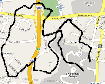
Many people independently know about the Leiper-Smedley Trail, the bike path that runs past those old garden ruins near the Blue Route. I've been on the commonly-traveled section between Plush Mill Road and Avondale Road many times but never the northern end. Where could it go?
Three minutes later, I knew: the trail runs flat to the Baltimore Pike / I-476 interchange with the set-back light that I always almost run, crosses the road, and ends in a small park with a picnic table up on a small rise. A pretty spot, allowing for the 10 lanes of traffic running just a few hundred feet away. A couple of dog-walkers had set up shop so I continued onto a well-defined dirt path heading towards the highway. One trail leading towards the trolley tracks was blocked by two young rough toughs so I turned left towards the freeway.
Andy and Annette memorialized their love in a large oak in 1973, and others had left their mark later in the 70s, all before the Blue Route made this a far less attractive place to hang out. Surprisingly, the trail led right under the highway, the supports of which being completely covered with graffiti. Once across, a couple of man-made bike jumps loomed as the trail turned uphil, and a number of fresh-looking treads made me lower my ipod volume a little.
The Pike broke back into view and we followed it up a fenceline before the fence ended and a side path went over to the pavement. Crossing five lanes of traffic is fun! Memories of running across to route 1 from work for Skin Sandwiches kept the good times rolling as I continued straight across onto Turner Road. This is the road you end up on if take Avondale Road down by the condos and never figure out which road to take over to PA-252. The shoulder was narrow, but the traffic was slow and the walking pleasant. Passed by an entrance to Furness Park, a Nether Providence presentation. Next time...
A number of dead-end left turns into small developments passed before the turn to Rogers Lane, just across from the road to the Wallingford train station. This is the road that comes out on Wallingford Road just W of where the trail through the Crum ends. After passing a gardener and studiously avoiding eye contact, I hung a right onto the southbound section of Leiper-Smedley.
One time, I crossed the Crum going in the other direction and found a trail back to the bike path, but trying to make the return trip didn't go so well. There were beaten paths down to the area by the railroad trestle, but down there was just mud and prickly stuff and no clear place to cross anyway. The only well-defined path led back upstream, but I figured the old crossing point was somewhere nearby so I headed that way. The water must have risen or something, since it never showed, but the path was easy to follow past biology experiments and petroleum pipeline signs. Four white-tailed deer ran up a hill as I blundered near.
Finally, I came out back on Wallingford Road, crossed on the bridge, and was back on the regular trail through the Crum. I was late for dinner and tried to run home, which was a really bad idea.
No comments:
Post a Comment